Saturday, April 13, 2019

The Bay of Fundy


http://bwlpublishing.ca/authors/donaldson-yarmey-joan

I started my writing career as a travel writer, researching and writing seven travel books about the attractions, sites, and history along the backroads of Alberta, British Columbia, the Yukon, and Alaska. While working on them I realized what a beautiful country I live in. Since then I have switched to writing fiction but I still love to travel. 2017 was Canada’s 150th birthday and to celebrate it my husband, Mike, and I travelled in a motorhome from our home on Vancouver Island on the Pacific Ocean to Newfoundland on the Atlantic Ocean. The round trip took us nine weeks and we were only able to see about half of the sites and attractions along the roads.

Today I’d like to describe our stop at the Bay of Fundy situated between the provinces of New Brunswick and Nova Scotia. The Bay has the highest tides in the world and was formally designated one of North America’s seven wonders of nature in February, 2014. (The others are Niagara Falls, Grand Canyon, Yellowstone National Park, Mount McKinley, the Everglades, and Yosemite National Park).


       From Moncton, NB, we drove south on Route 114 to Hopewell Cape and the Hopewell Rocks arriving in the afternoon. It was low tide so after we paid, Mike accepted the cart ride offered while I decided to walk the trail to the Rocks. I arrived at a viewpoint overlooking the ocean floor and the reddish rock structures.  Mike and I took the stairway down to the floor and wandered out among the tall formations. The ground was surprisingly solid with a few muddy areas.

       The Hopewell Rocks were originally a massive mountain range that was older than the Appalachians and bigger than the Rocky Mountains in Canada. Over millions of years the range wore down and after the retreat of the glaciers during the last ice age, water seeping through cracks in the cliffs eroded the sedimentary and sandstone and separated the Rocks from the cliffs. The incoming and outgoing tides have eroded the base of the rocks at a faster rate than the tops and that has caused their unusual shapes. Those shapes and the vegetation growing on top have given the formations their nickname of the Flower Pot Rocks.


       Due to the tides the Rocks are covered in water twice a day. Some visitors are able to see the high and low tides in one day but since the next high tide would be at night, Mike and I found a place to camp and returned to the Rocks the next morning. There is approximately six hours between low and high tide and the entrance fee covers a return visit to enable visitors to see the Rocks during both tides.

       Again, Mike took his ride and I walked. I reached the viewpoint and the change was astonishing. Just the tops of some of the rocks showed, the rest being under water. The tides can reach a height of 16 metres (52ft), which is as high as a four story building, twice a day. I walked down part of the stairs but the rest was blocked off to the public because they were under water. High tide is a good time to take a kayak tour and three kayakers were paddling around the formations.


       Seeing all the water and the partial formations, it was hard to believe that just the day before I had walked on the floor of the bay. It was an amazing experience.

Wednesday, March 13, 2019

Lucy Maud Montgomery and Prince Edward Island


http://bwlpublishing.ca/authors/donaldson-yarmey-joan

 
I started my writing career as a travel writer, researching and writing seven travel books about the attractions, sites, and history along the backroads of Alberta, British Columbia, the Yukon, and Alaska. While working on them I realized what a beautiful country I live in. Since then I have switched to writing fiction but I still love to travel. 2017 was Canada’s 150th birthday and to celebrate it my husband and I travelled in a motorhome from our home on Vancouver Island on the Pacific Ocean to Newfoundland on the Atlantic Ocean. The round trip took us nine weeks and we were only able to see about half of the sites and attractions along the roads.
       I have decided to write about the scenery, attractions, and history of my country. This post is about Lucy Maud Montgomery.

The Confederation Bridge connects Borden-Carlton, Prince Edward Island, with the rest of Canada at Cape Jourimain, New Brunswick. It is the longest bridge in the world that crosses ice-covered water and was completed in 1997 at a cost of $840 million.


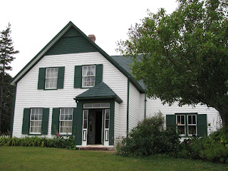
     We paid our toll and drove the bridge over the 12.9 kilometre wide Northumberland Strait. We headed to Green Gables in Cavendish in the Prince Edward Island National Park. One of the most famous writers in the world was from Prince Edward Island. Lucy Maud Montgomery was born on November 30, 1874 in New London, PEI. Her ancestors came from Scotland in the 1770s and her grandfathers were members of the provincial legislature for years. Her mother died of tuberculosis when Lucy was 2 and Lucy spent a much of her childhood with her maternal grandparents on the Macneill homestead in Cavendish. Her father moved west in 1887 and remarried. Lucy joined him but felt out of place and soon returned to PEI and her grandparents. She also spent time with her extended family on her mother’s side and her paternal grandfather.
     However, her grandparents weren’t very affectionate and Lucy felt lonely and isolated. This led her to reading an abundant number of books and using her imagination to write her own stories. She started with poetry and journals when she was nine years old and had her first poem, On Cape Le Force, published in the Charlottetown Patriot in November 1890. She started writing short stories in her mid-teens. She first published them in local newspapers then sold them to magazines throughout Canada and the United States.
     Lucy studied to be a teacher and began teaching in a village school in the late 1890s. She was also writing and selling her works so that when her grandfather died in 1898, she was able to leave her teaching position and move in with her grandmother. Between then and 1911 she wrote and sold poems and stories and also worked in the post office on her grandmother’s homestead.
    Her first novel, Anne of Green Gables, was published in 1908 and was an instant bestseller. She got her idea from other novels written by women like Little Women and from a story she read about a couple who had arranged to adopt a boy but were sent a girl. The book sold more than 19,000 copies in the first five months and was reprinted ten times in the first year. It is still in print after more than a century. Lucy wrote two sequels, Anne of Green Gables: Anne of Avonlea (1909) and Anne of the Island (1915) plus five more Anne books over her lifetime. She had a total of twenty books, over five hundred short stories, and one book of poetry published before she died in 1942.
     In her private life,  Lucy had many suitors over the years and became secretly engaged to a distant cousin named Edwin Simpson in 1897. This ended with she began a romance with a farmer named Hermann Leard. Leard died in 1899 from influenza and Lucy threw herself into her writing. Lucy married a minister, Ewen Macdonald, after her grandmother died in 1911 and they moved to Ontario where Ewen had a parish. They had two sons, Chester and Stuart, and a third one who was stillborn. They moved to another village in 1926 and then, after Ewen was admitted to a sanatorium in 1934 and he resigned his parish, they moved to Toronto in 1935. Ewen died in 1943.
     The Green Gables House has been restored to match the descriptions in Lucy Maud Montgomery’s books. I toured through the historic site, seeing the exhibits in the Green Gables house and strolling the Haunted Woods and Balsam Hollow trails that were mentioned in her books.


     Prince Edward Island also boasts have Canada’s smallest library. It is one room with shelves of books along the walls and a table and chairs in the centre.


Wednesday, February 13, 2019

Cape Breton Island


http://bwlpublishing.ca/authors/donaldson-yarmey-joan/
 
Cape Breton Island

 I started my writing career as a travel writer, researching and writing seven travel books about the attractions, sites, and history along the backroads of Alberta, British Columbia, the Yukon, and Alaska. While working on them I realized what a beautiful country I live in. Since then I have switched to writing fiction but I still love to travel. 2017 was Canada’s 150th birthday and to celebrate it my husband and I travelled in a motorhome from our home on Vancouver Island on the Pacific Ocean to Newfoundland on the Atlantic Ocean. The round trip took us nine weeks and we were only able to see about half of the sites and attractions along the roads.
       I have decided to write about the scenery, attractions, and history of my country. This post is about Cape Breton Island.
       The Canso Causeway connects Cape Breton Island to the mainland of Nova Scotia. The rock-filled causeway is 1385 metres (4345 ft) long and has a depth of 65 metres (213 ft) which makes it the deepest causeway in the world.
       The Fortress of Louisbourg is situated on the east shore of the Cape Breton Island and well worth the visit.
       In 1713, the Treaty of Utrecht was signed and France ceded its claims to present day Newfoundland, the Hudson’s Bay territories in Rupert Land, and Acadia (Nova Scotia) to the English. France kept what is now Prince Edward Island, the small islands of Saint Pierre and Miquelon as well as Cape Breton Island. The settlement of Louisbourg was founded on the east side of Cape Breton Island in 1713, and between 1719 and 1745 the French built a fortified town. With its several thousand inhabitants it grew into a thriving and busy seaport in North America and was a key trading and military centre for the French in the New World. It was the base for the profitable cod fishery of the Grand Banks since salted and dried fish was an important food in Europe. The value of the settlement’s dried cod exports in 1737 was eight times higher than the value of the fur trade during the same period.


       In 1745, war was declared between France and Britain and the English launched an attack on Louisbourg. While the harbour was well defended, the low hills around the fortress provided cover for the attackers. The residents of the fortress held on for forty-six days before being captured. However, three years later the town was given back to the French by the Treaty of Aix-la-Chapelle.
       A second attack occurred in 1758. There was no strong French navy to defend the town against the 16,000 troops and 150 ships and after seven weeks it was again taken by the English. They occupied it until 1768. Eventually, they decided that it should never return to being a fortified French base and they destroyed the fortress.

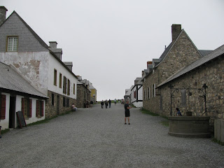
       Although the site was officially commemorated more than a dozen times with monuments, plaques, and cairns, it remained mainly forgotten and neglected until the 1930s when a museum was built and some of the streets and ruins excavated. In 1961, reconstruction began on one quarter of the fortress aided by the Government of Canada. First the area was excavated with the ruins of more buildings and walls being found as well as millions of artifacts. Since then streets, buildings, and gardens have been recreated so it looks as it did in the 1740s.
       The Fortress of Louisbourg is the largest reconstruction project in North America.
       I took a tour bus from the parking lot to the fortress. I visited with the guard at the entrance and began my tour. I walked up and down the streets of the fortress and toured through the buildings seeing the household furniture and goods of the period. There was an ice house where ice was placed during the winter and used during the summer to keep food cold so it wouldn’t spoil. I watched the fife and drum escort the cannon firers up the hill to the cannon and watched it being fired. I listened to the soldiers talk about their daily lives. I checked out the gardens and watched women doing embroidery. Throughout the site were interpreters in period clothing able to answer all questions about the fortress and its history. There is a long list of activities to do such as firing a musket or cannon, sampling some rum, learning a dance, or being a prisoner of the day.


       For those who want something to eat there are restaurants serving 1700s fare and a bakery from which you can buy a loaf of bread.
       From Louisbourg we drove the Cabot Trail, a 300 km (186 mile) scenic highway that took us through lovely villages, beside the ocean, up into the hills, and through Cape Breton Highlands National Park. The trail was named after John Cabot, an Italian explorer who landed in what is now Canada in 1497, and was completed in 1932.
 

       Alexander Graham Bell had a summer residence Baddeck. Now there is the 10 hectare (25 acre) Alexander Graham Bell National Historic Site which includes the Alexander Graham Bell museum.

       In Dingwall we visited the Tartans and Treasures Shop to find the Donaldson tartan. They had the MacDonald tartans in skirts, ties, vests, and on mugs and glasses but not the Donaldson tartan. I read a write-up there about Henry Donaldson who was one of the garrison at Edinburgh Castle 1339 to 1340 so the name has been around for centuries.


       Though not on the trail we stopped at Glenora Distillery in Glenville which is North America’s first single malt whiskey distillery. The whiskey made there smells and tastes like scotch but cannot be called scotch. That name is reserved for whiskey made in Scotland.
       There is a restaurant and bar that offers half ounce samples of the whiskey and I had my first, and last, taste. Even though my heritage is Scot, scotch is not my drink.

Sunday, January 13, 2019

The Vikings in North America

The Vikings in North America


I started my writing career as a travel writer, researching and writing seven travel books about the attractions, sites, and history along the backroads of Alberta, British Columbia, the Yukon, and Alaska. While working on them I realized what a beautiful country I live in. Since then I have switched to writing fiction but I still love to travel. 2017 was Canada’s 150th birthday and to celebrate it my husband and I travelled in a motorhome from our home on Vancouver Island on the Pacific Ocean to Newfoundland on the Atlantic Ocean. The round trip took us nine weeks and we were only able to see about half of the sites and attractions along the roads.

       I have decided to write about the scenery, attractions, and history of my country. This post is about the Vikings who had a settlement in the present province of Newfoundland more than one thousand years ago.

       After a seven hour ferry ride from Cape Breton we landed at Port aux Basque, Newfoundland, and headed north along Highway 1 to Corner Brook where we spent the night. In the morning we carried onto Deer Lake where we turned on Highway 430. We drove through Gros Morne National Park and along the Gulf of St. Lawrence. We were pleasantly surprised at the number of picturesque small fishing villages we passed through on our way north. Eventually we turned onto a smaller highway and reached the national historic site of L’Anse aux Meadows on the tip of the Western Peninsula of Newfoundland overlooking the Atlantic Ocean.

       It has been long thought that the first European to step on the soil of North America was Christopher Columbus. Excavations done at this site in the 1960’s recovered artifacts like jewellery, a stone oil lamp, a bone knitting needle, and tools that were compared to ones used at Viking settlements in Greenland and Iceland around the year 1000 and have been carbon dated to between the years 990 and 1050.


       From the parking lot I walked to the interpretive centre where I looked at the displays of what the settlement would have looked like during its occupation. There are replicas of the longships that the Vikings sailed in, artifacts unearthed during the excavations, write-ups about the Vikings, tools that were found, and maps showing the route the Vikings used to get to Newfoundland or Vinland, as they are thought to have named it. The Scandinavians of the medieval period were known as Norse and they were farmers and traders. When they began raiding other countries they became known as Vikings, the Norse word for raiders.

       There has been a lot of interest in the Vikings recently with televisions shows and documentaries about them and their raiding which began in the 790s and lasted until around 1050. With their longboats and advanced sailing and navigational skills the Viking men and women travelled from Scandinavia south through Europe to Africa, the Middle East, and Asia and west to North America.


       I left the centre and followed a long, wooden boardwalk through grass and small bushes to the actual site. There I found a post fence around a yard with large mounds covered in grass. When the Vikings landed here there were forests from which they were able to get material for their boat building and house building. The remains of eight buildings were found in the 1960s and they are believed to have been made of a wooden frame and covered with sod.

       They have been identified are a long house, an iron smithy, a carpentry shop, and smaller buildings that may have been for lower-status crewmembers or even slaves or for storage. There are three replicas of those sod buildings with their thick walls on the site. One is a long house which is equipped with clothes, beds and bedding, household utensils, tools, a fire pit and has a couple dressed in period clothing cooking a meal. The Vikings hunted caribou, bear, and smaller animals plus whale, walrus, and birds for food as well as fished.


       I wandered through the rooms divided by hand carved wooden plank walls. Light came from the fire and holes in the ceiling which are partially covered with upside down wooden boxes to keep the rain out.

       One of the other buildings is the smithy complete with anvil, forge, bellows and various tools. I wandered the rest of the site and saw the outlines of other buildings that have not been reconstructed. It is estimated that between 30 and 160 people lived there over the years.


       The Vikings arrived in Newfoundland from Iceland via Greenland. According to historical records the site was inhabited by the brothers and sister of Leif Ericson plus a series of explorers. It is believed the settlement was there for seven or eight years before being abandoned. This is the only confirmed Viking site in North America and is the farthest west that Europeans sailed before Columbus.

       After viewing the buildings I followed a trail along the rocky shoreline and then turned inland to walk on a boardwalk over a bog back to the parking lot.


       One of the best things is that not only does the interpretive centre have the history of the Vikings, but there is also extensive displays showing the history of the aboriginal people who inhabited the area over thousands of years before any European arrived.